Explanation
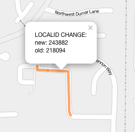
This interactive map shows 151 localid changes between the Jul 24 and Oct 27 release of the RLIS streets dataset. These changes, are generally due to the splitting of segments as finer grained data is added. This mapping from new to old id's is important because it allows third party data associated with the prior RLIS streets dataset to be automatically moved forward (joined) with the new version.
The localid difference data was generated with spiderosm. Spiderosm is an open source tool that joins data from disparate sources, or, as in this case, different versions from the same source, GEOGRAPHICALLY: no common keys or ids required.
Credits
- Basemap © OpenStreetMaps Contributors
- Localid Diffs found via SpiderOSM path network matching tool.
- RLIS streets data provided by Oregon Metro under Open Commons Database License (ODbL) and Content License (DbCL)